Statist. My first plugin for QGIS. That was a long time ago: 2009, QGIS 1.0.0, start of discussions about including fTools in the core (yes, fTools was a regular plugin that had to be installed manually), only a few third-party plugins, and almost no instructions on how to write Python plugins… And I was younger and didn’t know much (to be fair, I still have a lot to learn).
The last major update of the plugin was also in 2009: I was happy with the functionality, and there were no critical bugs. Later, as I gained knowledge and experience, I thought about refactoring several times, but it didn’t work out. And recently, something came over me, so I sat down and did it.
Users will probably not notice any difference, as there are not that many changes visible to them: only support for getting statistics on joined fields has been added. But there are many more changes under the hood:
the code to check for the presence of matplotlib has been rewritten
new signal-slot connection syntax is used
completely rewritten code for calculating statistics
unused and duplicate code was removed and classes were moved into separate files
system font is used for histogram labels
The plugin now lives in my repository, please report bugs and feature requests by mail or in the bugtracker (preferred).
I found out how to write plugins for SEXTANTE. It turns out there is nothing difficult about it, and SEXTANTE is great. It is a pleasure to write plugins for it. I started by adapting my first plugin, Statist, and now I’m thinking about porting all the other analytical plugins. And if all goes well, I will have my own toolbox with the modest name “Alex’s tools” :-).
The 7th QGIS developers meeting held in Lyon (France) has ended.
The first day was rather uneventful - the host university had problems with the electricity, and besides, almost everyone arrived in Lyon in the afternoon. The following days were more intense: presentations, discussions on various aspects of the project, and, of course, coding.
finances. If we leave out all the figures and details, the picture is as follows: costs are rising, but the balance is still positive
release model. The idea of multiple release branches has been abandoned, and all new releases will be made from the main tree. Release branches will only be used as “markers”, and to fix critical bugs (like the epic extent bug) after a release. Non-critical bugfixes will not be backported. There will be a freeze period (both for code and strings) before a release on the master branch.
migrating documentation from LaTeX to RST and setting up an online platform for translators. Actually, the migration has already started with the QGIS User Manual. The plan is to convert all project documentation to RST format
improving the testing infrastructure. New tests for different parts of the code have been added, and a testing server has been setup
Among the topics discussed were also the upcoming GSoC, integration of some 3rd-party plugins into the core (DB Manager was already integrated at the time of writing), API changes, and so on.
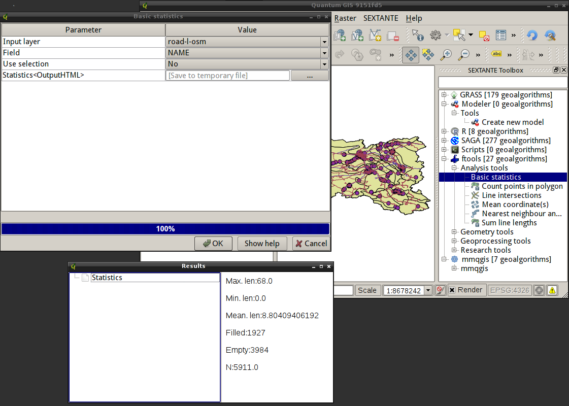
Victor Olaya has developed another framework for integrating various libraries and tools into QGIS. It is based on the SEXTANTE platform, which includes a toolbox, a graphical modeler and a script creator. It also provides a batch processing interface, command history, and some other features. The platform currently supports SAGA, GRASS, and R algorithms, as well as tools from the fTools and mmqgis plugins. According to the author, it is quite easy to add new algorithms and new providers.
I haven’t had a chance to test it properly yet, but it looks interesting and promising. The screenshot shows the list of tools, the GUI of the Basic Statistics tool from fTools and the result it produced.
SEXTANTE plugin in QGIS
Please note that this is still a work in progress, so regular users are better off waiting for the official release rather than using code from SVN.
Not long ago, people on the forum were looking for a way to consolidate the QGIS project and related layers into one place. As no such tool existed, the discussion quickly turned into a thread full of wishes and feature requests. A little later, I was faced with the same task. Fortunately, in my case, the project only had vector layers in Shapefile format, so I quickly developed a simple and somewhat suboptimal plugin.
Now that I have more free time, I am slowly improving the plugin. I have already implemented:
support of file-based vector datasources
support for native database providers (PostgreSQL, SpatiaLite, SQLAnywhere)
layer processing has been moved to a separate thread, and the tool no longer blocks the main QGIS window
initial support for GDAL rasters
On the TODO list:
support for all vector data providers
finalise support for raster layers
provide the user with a choice of vector data format (Shapefiles or SpatiaLite database)
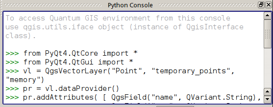
Most QGIS users are probably aware of the Python Console, even if they rarely use it. It is a window (accessible from the “Plugins → Python Console” menu) where you can interactively enter commands and access QGIS API functions.
QGIS Python Console
The Console is an extremely useful tool and comes to the rescue in many scenarios, from prototyping plugins to automating repetitive actions.
Obviously, typing commands every time you need to perform some task is inconvenient, so frequently executed code is transformed into scripts, and these scripts are then run from the Console. However, if the number of actively used scripts is large enough, using the console becomes a bit inconvenient. The Script Runner plugin by Gary Sherman was developed to solve this problem. The plugin is available from the official repository, has no dependencies, and can be found in the “Plugins” menu after installation.
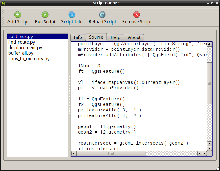
The plugin’s interface is simple: a toolbar with large buttons, a list of scripts on the left, and four tabs — “Info”, “Source”, “Help” and “About” — on the right.
Script Runner plugin
The “Add Script” and “Run script” buttons are self-explanatory: the first one adds a script to the list (the list is saved between sessions), the second one runs the selected script.
Clicking the “Script Info” button will populate the “Info” tab with docstrings, function and class names from the selected script, and the script code will be loaded into the “Source” tab in read-only mode.
I think the purpose of the last two buttons, “Reload Script” and “Remove Script” is clear from their names. The first reloads the script (useful for debugging or if you need to tweak the code and run the process again), and the second removes the script from the list (leaving the file on disk).
Script Runner has only one requirement for scripts: they must have an entry point. The entry point is simply a run_script function that takes only one argument, a reference to the qgis.utils.iface object. If such a function is not present in the code, the script will simply not be recognised and loaded by the plugin.
The script logic can be implemented either within the run_script function or in separate functions called from it. It is also possible to use an OOP approach. In this case, you need to create an instance of the class in run_script and call the necessary method(s).
Here is a simple example (the script creates an empty LineString memory layer):
I’ve already posted a couple of beautiful videos showing the QGIS development process (first, second) made with Gource. Here are a few more, this time made by myself.
A complete history, from the beginning of development to 25 January 2012.
Developers activity from 1 September 2011 to 26 January 2012 (805 commits were made)
With the release of QGIS 1.7.0 it was announced that a new official plugin repository has been created with many features (a rating system, lists of recommended and recently added plugins, etc.). In addition, a dedicated section for 3rd-party plugins has been created in the QGIS bug tracker, where plugin authors can create a homepage, wiki, bug tracker, and code repository for their plugins. The main goal of all this is to provide a single repository for plugins and a single place to report bugs for both plugins and QGIS itself.
And although the new repository has been put into production and added as the default repository in the QGIS 1.9.90, plugin developers are still holding back on using it (at the time of writing, there are only 35 plugins in the new repository, for comparison, there are 111 plugins in the old repository). This can probably be explained partly by ignorance and partly by the somewhat confusing procedure for adding a plugin to the new repository.
Let’s try to figure this out.
I assume that the plugin code has been published to one of the public code repositories, such as GitHub or BitBucket, and now we want to set up a bug tracker and wiki on hub.qgis.org. This will make life a bit easier for users: they will be able to use their existing account to file bug reports. To do this:
go to hub.qgis.org and log in
open the “Projects” section and click on the “New Project” button, or go to the “User Plugins” subsection and click on the “New Subproject” button
fill in the form (note that in the “Subproject of” list you should select “User plugins”): enter the name of the plugin, a short description, and a link to its homepage (if available). Here, you can also select the necessary components of the bug tracker (wiki, tracker itself, calendar…). Most settings can be changed later
once you have completed the form, click on the ‘Save’ button. That’s it, a new project has been created
The bug tracker and code repository are ready. All we need to do now is upload the plugin to the plugins repository.
Before creating an archive and uploading it to the server, we need to fill in the metadata in the plugin’s metadata.txt file, specifying the URLs of the bugtracker, repository and homepage (more details). Here’s an example:
[general]name=Cool Plugindescription=Does some useful actions with your datacategory=Vectorversion=1.0.0qgisMinimumVersion=1.7.2icon=icons/pluginicon.pngauthorName=usernametags=vector, bounding box, bufferexperimental=Truedeprecated=Falsehomepage=http://someserver.com/coolplugin.htmltracker=http://hub.qgis.org/projects/coolpluginrepository=http://github.com/username/coolplugin
Save the changes in the metadata.txt file and create an archive with the plugin. Now we are ready to upload the plugin to the new repository:
use the “Share a plugin” link in the sidebar to open the upload form
select the plugin archive, activate the “Experimental” checkbox if necessary, and click “Upload”
If the plugin is packaged correctly and the metadata contains no errors, the archive will be uploaded to the server. Otherwise, an error message is displayed, and the upload is cancelled. Once the errors have been corrected, the upload should be repeated.
The uploaded plugin gets an unapproved status and is not immediately available to all users. It will only be added to the list of publicly available plugins after approval from the administrator. This will happen every time you upload a new version, even if your plugin has already been approved. This policy may be changed in the future.
There is also a small script to upload the plugin archive to the server. For example, you can add it to the post-commit hook or Makefile and upload new versions without a browser.
As you can see, there is nothing complicated about using the new infrastructure.
In general, the proposed changes were well received and sparked another wave of discussion about the plugin situation. At the same time, the main drawback of the proposed approach was pointed out — now, after activating a plugin, it is not known in which menu it will appear. To solve this problem, the Plugin Manager had to be modified, and another tag had to be added to the plugin metadata.
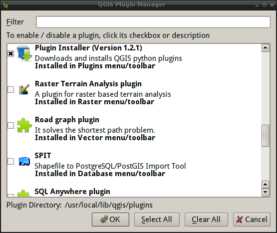
The new category metadata is for informational purposes only and should contain the name of the menu where the plugin will be placed after activation. This information is displayed in the Plugin Manager.
Category metadata in the Plugin Manager
If there is no category metadata, the default value “Plugins” is used.
Oh, and one more thing. Plugins written in C++ need to be recompiled. It is a small API break.
It is still the responsibility of the plugin developer to place the plugin in the correct menu, and there are many API calls available for this purpose. These methods can be used to add the plugin to any menu or toolbar.
What’s this all about? Well, about 20 minutes ago, it stopped being an experimental branch and was merged into master. So if you don’t find “Add Delimited Text Layer” in the “Plugins” toolbar tomorrow, don’t say you weren’t warned :-).