Tag: Qgis

CSWClient plugin for QGIS

06.01.2011 07:03 ·  GIS  ·  qgis, plugins, cswclient

I have released a first experimental version of the CSW Client plugin for QGIS.

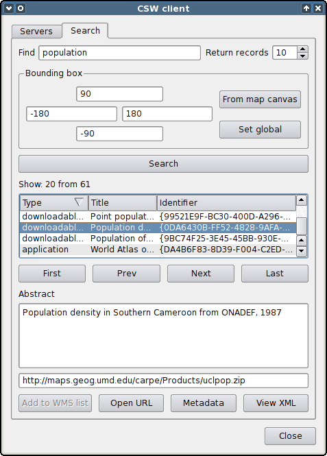
The plugin interacts with the OGC CSW (Catalogue Service for Web) servers and is used to search and view spatial data and related resources.

CSWClient plugin dialog

Among the main features of the plugin:

CSWClient is available from the QGIS plugins repository.

The plugin was developed for Linfinity Consulting for the TanBIF (Tanzania Biodiversity Information Facility) project.

kCube poll

21.12.2010 06:59 ·  GIS  ·  qgis

A few days ago I wrote about the kCube Consulting initiative. The ideas have been collected, and the voting has started. Unfortunately, you can only vote for one option.

So far “Fixing bugs” is leading with 23.8%, followed by “Improving import/export on dwg/dxf” with 8.8% and “QGIS Mobile (e.g. on Android)” with 7.5%.

QGIS Plugin Manager with icons

13.12.2010 17:19 ·  GIS  ·  qgis

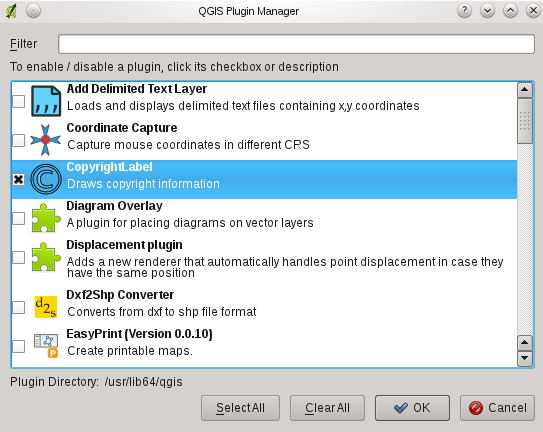
This is how the QGIS Plugin Manager looks like after adding icons to plugins.

QGIS Plugin Manager with icons

News from the QGIS front

13.12.2010 16:04 ·  GIS  ·  qgis

Tim Sutton gave a good overview of some new features in QGIS: a graphical rule editor (which helps to create rendering rules) and complex styles for vector objects (fill, outline and centre marker).

Yesterday, Martin Dobias added icon support to the QGIS Plugin Manager. Among other things, this will make the display of available plugins more user-friendly and make it easier to navigate through the large list. However, to take advantage of this feature, plugin authors will need to make small changes to their code (add two lines). In the future, after the launch of the new plugin repository, it is planned to add icon support to the Plugin Installer.

Another interesting news — kCube Consulting has decided to help the QGIS project by assigning one of their programmers to work on QGIS for 6 months. You can read more about this on Tim’s blog, and visit the wiki to check out the list of possible tasks and leave your own suggestions.

/me put on “Sax & Sex” and began to add icon support to his plugins and those he could reach.

QGIS vs. MapInfo

07.12.2010 14:54 ·  GIS  ·  qgis

A small but interesting comparison of QGIS and MapInfo https://woostuff.wordpress.com/2010/12/06/mapinfo-and-qgis-an-overview/.

QGIS 1.6 "Copiapó"

29.11.2010 14:56 ·  GIS  ·  qgis, release

QGIS 1.6 “Copiapó” has been released. This version contains over 177 bugfixes and many improvements. Among the most interesting changes are:

An updated User Guide is also available (English only for now).

MergeShapes update

22.11.2010 17:27 ·  GIS  ·  qgis, plugins

I decided to improve my MergeShapes plugin a bit. I added encoding selection when opening files, shapefile geometry type selection and reworked the merge algorithm. Now, the final attribute table contains all unique fields from all input files, which means you can merge files with different attribute tables. The only missing bit is a setting for the default encoding of input data.

There are plans to improve DPSimplify, Statist and RasterCalc, but I don’t know how it will go yet.

I’ve also started to slowly learn Git, or rather to organise and deepen my fragmentary knowledge. I want to try out this VCS in real tasks, as there is already a Git mirror of the main QGIS SVN repository.

QGIS hackfest 2010 (Wrocław)

16.11.2010 12:43 ·  Notes  ·  qgis, meetings

Based on the report published on the Linfiity Geo Blog and my own impressions.

The 4th QGIS hackfest, held from 11 to 15 November in Wrocław, Poland, attracted 29 participants (28 people and one dog). All participants did their best to make QGIS even better. A lot was accomplished in four days: hundreds of commits, demonstrations of new features, and many productive discussions. The meeting was organised by Paweł Netzel with the help of Milena Nowotarska, Robert Szczepanek, Maciej Sieczka and Borys Jurgiel and took place at the Department of Climatology and Atmospheric Protection of the University of Wroclaw.

My contribution — numerous improvements to the fTools plugin. When using the “Merge shapefiles to one” tool, it is now possible to select not only a folder, but also individual files. The “Simplify geometry” tool has been redesigned: I added a customisable simplification threshold and the ability to simplify the whole layer or only selected features; simplification can be done “in place” or by creating a new shapefile; “in place” simplification supports undo/redo; at the end of the simplification plugin shows a report about the total number of vertices in a layer before and after simplification.

Below, you will find an overview of the most important topics that were discussed during the hackfest as well as most notable changes.
Read more ››

RasterCalc: from Python to C++

15.10.2010 17:41 ·  GIS  ·  qgis, plugins, rastercalc

Yesterday I found out that my plugin — RasterCalc — was only announced on the QGIS mailing lists. I didn’t post anything on the forum or here. I don’t know how I could have forgotten. Although I have to admit that there was a lot of work going on at the time: RasterCalc itself, an experimental branch of GDAL Tools, Photo2Shape and many other things. QGIS 1.4 was released in January… I know it’s a weak excuse, especially considering that other plugins were announced all over the place, but I don’t have any others.

So… RasterCalc is a user-friendly and functional raster calculator written in Python. It was announced on the mailing lists on 16 January 2010.

RasterCalc window
RasterCalc window

RasterCalc was inspired by Barry Rowlingson’s RasterLang plugin. The main difference is the user-friendly interface and the familiar expression syntax (do you like LISP as much as Barry?). I have also added some additional features like saving and loading expressions, “templates” of formulas and extended the set of available functions and operators.

Weeks and months went by (I almost wrote “years”), nothing seemed to indicate any changes… And then, out of the blue, Marco Hugentobler and Tim Sutton decided to make RasterCalc part of the QGIS analysis library. This will allow its features to be used by other plugins, and remove the dependency on NumPy, pyparsing and other Python modules.

Marco has already published a first version of the patch. Some features are missing compared to the original plugin:

At the same time, new features have been added:

QGIS Raster Calculator

You can try out the new functionality by applying the patch and building QGIS from source. The calculator will appear in the “Layer → Raster calculator” menu.

The patch is still under development and some things may not work. The authors invite everyone to try it and report any bugs (if possible, attach a test dataset and steps to reproduce the issue).

QGIS User Guide in Russian

15.10.2010 15:48 ·  GIS  ·  qgis

Yay! The collaborative project to translate the QGIS 1.5 User Guide into Russian is finished. It took 1 month and 18 days, and 15 people participated.

During the translation process, many typos and inaccuracies were found, which, in the best tradition of open source, were corrected not only in the translated version but also in the original manual. Thanks to the perseverance of the project members, several major problems in the English version, such as the lack of a subject index and bibliography, have been fixed.

The translated user manual (PDF format, ~10 Mb) is now available on the QGIS website.