SEXTANTE is a powerful and flexible platform for performing geospatial analysis in QGIS. It provides access to its own geoprocessing functions as well as algorithms implemented in third-party applications, making analysis easier and more productive.
Initially written in Java and only available to gvSIG users, SEXTANTE has gradually extended its presence to other GIS. In 2012, a Python version was developed for use with QGIS. It immediately attracted a lot of interest from users and developers alike, and in September 2012 SEXTANTE was integrated into QGIS as a core plugin.
SEXTANTE in QGIS allows you to use the main features of well-known third-party GIS tools (SAGA GIS, GRASS GIS, TauDEM, OrfeoToolBox…) and algorithms implemented directly in SEXTANTE (fTools, MMQGISX…) via a unified interface.
It also offers a wide range of possibilities for automating data processing: combining repetitive steps of applying algorithms to data in a custom analysis model, writing and using Python scripts, batch processing mode. Advanced users can further increase their productivity by using SEXTANTE algorithms and the Python console together.
Attempts to import SEXTANTE from its SVN repository into the QGIS repository on GitHub with the history intact are a thing of the past. Also in the past were numerous fixes for bugs that appeared after the import, writing build rules, and fixing issues caused by the directory structure change. SEXTANTE is now officially included in QGIS as a core plugin.
Thanks to Victor, Tim, Camilo. Well, and me too :-).
Together with Victor, we have implemented in SEXTANTE the ability to save output to any OGR-compatible format or memory layer and to set the output data encoding. The only thing missing is the ability to set dataset and layer creation options. In the future, we plan to add support for saving results to spatial databases.
In the meantime, we are fixing bugs and making sure that all the algorithms are fully functional. In particular, there are 16 algorithms in fTools that are still untested.
Reviewed 19 fTools tools in two groups: cleaned up the code, fixed some bugs, optimised a bit. There is still as much to do. Then test and if no critical bugs appear, I will commit.
SEXTANTE will soon become part of QGIS: the code freeze in the old repository and the migration are scheduled for 20th August. After the migration, only the Java-related part will remain in the old repository, while QGIS will get a new core plugin.
In this context, I have decided to revise the fTools provider code, synchronise it with the original utilities, and generally prepare for migration and code removal in any way possible. I will be happy if someone helps with testing and is willing to publish plugin package with the latest fixes.
There is a software called TauDEM (Terrain Analysis Using Digital Elevation Models). It provides a free (GNU GPL v2) set of tools for extracting and analysing hydrological information from digital elevation models. TauDEM is developed by David Tarboton of the Water Research Laboratory at Utah State University.
The tools are written in C++, are cross-platform, and have a console interface. Users of ArcGIS 9.3.1 and 10.0 can install an add-on that allows them to run the tools from ArcToolbox using simple dialogs. For others, the only way to use TauDEM is the “scary” command line.
Recently, QGIS also got a powerful and convenient framework that allows easy integration of various tools and libraries (yes, I’m talking about SEXTANTE). Thanks to this framework, QGIS users who need hydrology tools now have a way to use TauDEM directly from QGIS.
Of course, you need to have TauDEM installed in order to use the plugin. While the installation on Windows is quite simple (there are compiled files and detailed installation instructions on the site), Linux users will have to build TauDEM themselves.
I found out how to write plugins for SEXTANTE. It turns out there is nothing difficult about it, and SEXTANTE is great. It is a pleasure to write plugins for it. I started by adapting my first plugin, Statist, and now I’m thinking about porting all the other analytical plugins. And if all goes well, I will have my own toolbox with the modest name “Alex’s tools” :-).
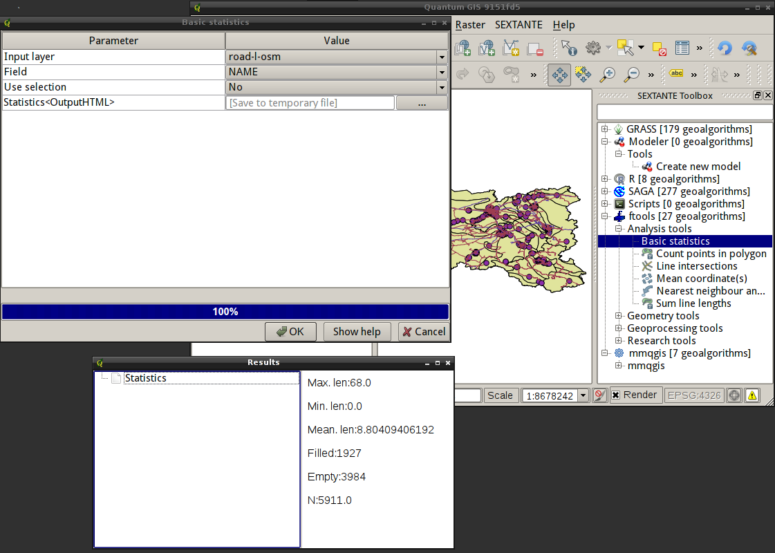
Victor Olaya has developed another framework for integrating various libraries and tools into QGIS. It is based on the SEXTANTE platform, which includes a toolbox, a graphical modeler and a script creator. It also provides a batch processing interface, command history, and some other features. The platform currently supports SAGA, GRASS, and R algorithms, as well as tools from the fTools and mmqgis plugins. According to the author, it is quite easy to add new algorithms and new providers.
I haven’t had a chance to test it properly yet, but it looks interesting and promising. The screenshot shows the list of tools, the GUI of the Basic Statistics tool from fTools and the result it produced.
SEXTANTE plugin in QGIS
Please note that this is still a work in progress, so regular users are better off waiting for the official release rather than using code from SVN.