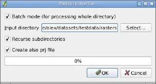
Extract Projection tool for QGIS
28.07.2011 11:40 · GIS · qgis, gdaltools
In addition to the previous post.

28.07.2011 11:40 · GIS · qgis, gdaltools
In addition to the previous post.

06.06.2010 13:07 · GIS · qgis, plugins, gdaltools
GdalTools (or Raster Tools) is a plugin for the open source GIS QGIS. The main purpose of the plugin is to simplify the use of the GDAL command line utilities by providing the user with a graphical interface for the most common operations.
Initially, the plugin was developed by Faunalia, later other developers, including myself, joined them. Robert Szczepanek created nice icons for most of the tools, and the development of some features was sponsored by Silvio Grosso.
At the time of the first announcement (September 2009), the plugin provided only two tools: gdalbuildvrt and gdal_contour. Now the number of integrated tools is approaching 20.
03.02.2010 15:36 · GIS · qgis, plugins, gdaltools
Today we merged the experimental branch of the GdalTools plugin into the main development branch.
GdalTools (aka Raster Tools) provides users with a simple graphical interface to perform the most common raster processing tasks. Originally the plugin was created by Faunalia (Paolo Cavallini, Giuseppe Sucameli and Lorenzo Masini), the icons for the extension were created by Robert Szczepanek. About a month ago I also joined the work (and this experimental branch is my work).
This is what we ended up with:
23.12.2009 16:28 · GIS · qgis, plugins, gdaltools
I’ve already submitted some patches for fTools, now it’s time to look at GdalTools. I have already added an “Info” tool to display information about the raster, implemented internationalisation support, added several new options to the “Merge” and “Warp” tools, and now I am working on a batch mode. There are also plans to add more tools.
Hopefully I will be able to get most of the work done before the New Year, and then I will start improving Statist and developing another plugin.