I returned to Zaporizhzhia yesterday, sunburned and a little refreshed. The heat in Crimea is terrible, and the proximity of the sea does not help. In Choban-Kale, at 11 o’clock in the afternoon, we had 53°C in the direct sun (they say it was almost 60°C in Simeiz), and the water temperature was ~28–29°C. However, it is no better in Zaporizhzhia.
While I was on holiday, the next version of QGIS — 1.5.0 “Tethys” — was released. The official announcement is on the QGIS blog. There are many changes: a lot of bugs have been fixed, new tools have been added, and old tools have been improved (fTools, GdalTools, annotations, new georeferencing module). The documentation is actively updated.
Marco Hugentobler has implemented initial support for table joins in QGIS. If you want to try out the new functionality, you can get the source code from the new branch of the repository
svn co https://svn.osgeo.org/qgis/branches/table_join_branch table_join
and build it.
To join a table to a layer’s attribute table, you need:
add a vector layer to a project
add a table to a project (e.g. by going to the “Layer → Add vector layer” menu and selecting a *.csv or *.dbf file)
open the vector layer properties dialog and select a “Join” section. Then click on a “+” button to add a new joinJoining a table to a vector layer
select the fields that will be used to create the join and press “OK” button
new fields from the joined table should appear in the layer’s attribute table, as well as in the “Attributes” tab of the layer properties dialogue and in the “Identify Results” dialogue
As this feature is still in the early stages of development, there are some issues:
joined fields are read-only, their values cannot be changed
poor performance, especially when performing classification or searching on joined fields
I have noticed that recently many people have asked how to get image coordinates (row, column) from real world coordinates (latitude/longitude). The following code shows how to do this in the QGIS Python console:
GdalTools (or Raster Tools) is a plugin for the open source GIS QGIS. The main purpose of the plugin is to simplify the use of the GDAL command line utilities by providing the user with a graphical interface for the most common operations.
Initially, the plugin was developed by Faunalia, later other developers, including myself, joined them. Robert Szczepanek created nice icons for most of the tools, and the development of some features was sponsored by Silvio Grosso.
At the time of the first announcement (September 2009), the plugin provided only two tools: gdalbuildvrt and gdal_contour. Now the number of integrated tools is approaching 20.
GDAL is a free library for working with raster and vector data, OGR is a part of the GDAL and is used to work with vector data. The command line utilities included in the library are widely used to perform a variety of tasks. Thanks to the developed API, you can work with OGR functions from many programming languages. This article is dedicated to using the OGR API in Python and is based on the GDAL Vector API Tutorial.
GDAL is a free library for working with raster and vector data. The command line utilities included in the library are widely used to perform a variety of tasks. Thanks to the developed API, you can work with GDAL functions from many programming languages. This article is dedicated to using the GDAL API in Python and is based on the GDAL Raster API Tutorial.
Today we merged the experimental branch of the GdalTools plugin into the main development branch.
GdalTools (aka Raster Tools) provides users with a simple graphical interface to perform the most common raster processing tasks. Originally the plugin was created by Faunalia (Paolo Cavallini, Giuseppe Sucameli and Lorenzo Masini), the icons for the extension were created by Robert Szczepanek. About a month ago I also joined the work (and this experimental branch is my work).
This is what we ended up with:
the plugin is localised. In addition to the default English interface, there are Ukrainian and Russian translations (though not yet complete).
new tools: “Information”, “Build Overviews”, “Assign Projection”, “Clipper”
batch mode for tools “Build Overviews”, “Translate” and “Reproject”
new parameters “Use intersected extent” and “Layer stack” have been added to the “Merge” tool
it is now possible to change the output image size when reprojecting raster
almost all tools now have “smart” selectors - combined fields that can be used to select either the map layer or the file(s) on the disc.
results can be saved not only in GeoTiff, but also in any other format supported by the corresponding tool.
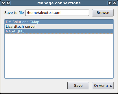
Yesterday my patch adding import/export of connection settings to geodatabases and WMS servers was accepted.
When the user clicks on the import/export button, the following simple window appears
Manage connections dialog
The file to which the data will be written (or from which it will be imported) is selected at the top, and the connections from that file are displayed below. Multiple selection can be made using the Ctrl and Shift keys, also list items can be selected by dragging the mouse.
Once you have saved the file, you can transfer it to another machine and add the necessary connections in a few clicks.
I also forked Tim’s ImagesToShape plugin, rewrote it to use the EXIF.py module and added some improvements. This is how Photo2Shape was born. It is already released, but there is not much feedback yet, or rather none at all :-).
Recently Tim Sutton published a blog post about geotagging with free software and released his QGIS plugin for it. The plugin uses the exiv2 library and requires the python-exiv2 package, which is not available on Windows/OSGeo4W. Therefore ImagesToShape is not available from the plugins repository.
As I’m interested in geotagging myself, I contacted Tim and offered to rewrite the plugin, abandoning exiv2 in favour of a pure Python module.
QGIS 1.4 “Enceladus” has been released, the announcement can be found on the official blog. This release contains over 200 bug fixes and about 30 new features. It is notable for a new symbology system, a more advanced PAL-based feature labelling engine and other improvements.
Meanwhile, the developers are working on the trunk: it is already possible to reload Python plugins without restarting QGIS, the Python console has been practically rewritten, support for GPS devices has been added, diagrams and plots now use Qwt…
And there is another hackfest planned for the end of March in Italy, details here. I’d love to go, but I don’t know if I’ll be able to.