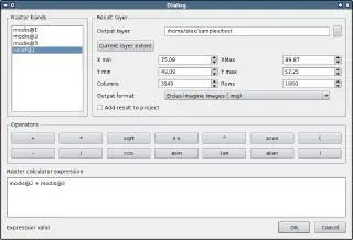
QGIS package with Raster Calculator
Follow-up to the previous post about the QGIS raster calculator.
I have created an OSGeo4W-compatible QGIS package (based on r14380) with applied Marco’s raster calculator patch and uploaded it to the forum. QGIS has been built with GRASS and Python support and uses GDAL 1.7.2 (all dependencies are from OSGeo4W). To use it:
- install QGIS and all its dependencies using the OSGeo4W installer
- download the package from the forum thread
- extract the contents of the package to the OSGeo4W root directory (by default this is
C:\OSGeo4W) - open the OSGeo4W shell and run
qgis-calc.bat
Raster Calculator can be opened from the “Layer → Raster calculator” menu.

Once again, I would like to remind you of the authors’ request: report all bugs and, if possible, include a test dataset and steps to reproduce the problem.