QGIS vs. MapInfo
A small but interesting comparison of QGIS and MapInfo https://woostuff.wordpress.com/2010/12/06/mapinfo-and-qgis-an-overview/.
Here I post my thoughts, QGIS tips and tricks, updates on my QGIS-related work, etc.
A small but interesting comparison of QGIS and MapInfo https://woostuff.wordpress.com/2010/12/06/mapinfo-and-qgis-an-overview/.
29.11.2010 14:56 · GIS · qgis, release
QGIS 1.6 “Copiapó” has been released. This version contains over 177 bugfixes and many improvements. Among the most interesting changes are:
An updated User Guide is also available (English only for now).
25.11.2010 19:03 · Notes · linux
After reading manuals and smart books, I decided to migrate some of my local SVN repositories to Git. It would seem to be a simple process, but no… there were some problems.
I’m running DeepStyle 3.1 (which is basically Slackware 12.2). Git 1.6.1.3 was installed with the system.
So I created a directory for the project, ran git-svn and got a “command not found” error. The first problem turned out to be quite simple, you have to use git svn (at least on Slackware), i.e. without the hyphen. Strange, almost all articles refer to git-svn…
OK, I tried to run the correct command and got a scary error message
Can't locate Error.pm in @INC (@INC contains: /usr/lib/perl5/site_perl/5.8.8/i486-linux-thread-multi /usr/lib/perl5/site_perl/5.8.8 /usr/lib/perl5/5.8.8/i486-linux-thread-multi /usr/lib/perl5/5.8.8 /usr/lib/perl5/site_perl /usr/lib/perl5/vendor_perl/5.8.8/i486-linux-thread-multi /usr/lib/perl5/vendor_perl/5.8.8 /usr/lib/perl5/vendor_perl .) at /usr/lib/perl5/vendor_perl/5.8.8/Git.pm line 93.
BEGIN failed--compilation aborted at /usr/lib/perl5/vendor_perl/5.8.8/Git.pm line 93.
Compilation failed in require at /usr/bin/git-svn line 45.
BEGIN failed--compilation aborted at /usr/bin/git-svn line 45.
This one took a bit longer. It turned out that I needed to install additional Perl modules and the corresponding bindings for SVN. To install the modules, use the following command (internet access required):
sudo cpan Alien::SVN Error Term::ReadKey
Wait for the installation to finish. Now download subversion-bindings SlackBuild. Extract the archive, change the SVN version in the script to the one you are using and run it. Wait for it to compile and then install the package that was created. Everything should be working now.
The actual repository migration is quite simple (at least in my case). First, we need to match the usernames in SVN and Git, so we create a text file with the following content (of course, the names should be real):
jdoe = Jon Doe
tomm = Tom Morton
Then create a temporary directory for the project, initialise the Git repository, and import the sources from SVN:
mkdir project_tmp
cd project_tmp
git svn init http://svn.somehost.net/project --no-metadata
git config svn.authorsfile ~/tmp/svn_authors
git svn fetch
The --no-metadata switch in the third command is needed to ignore SVN-specific information. The fourth command creates a mapping between Subversion and Git usernames using a previously created file. The last command performs the import of the source code. The import process will take some time (depending on the size of the repository and the number of commits). Once it has finished, you can clone the temporary repository to get rid of any garbage left behind by SVN.
cd ..
git clone project_tmp project
22.11.2010 17:27 · GIS · qgis, plugins
I decided to improve my MergeShapes plugin a bit. I added encoding selection when opening files, shapefile geometry type selection and reworked the merge algorithm. Now, the final attribute table contains all unique fields from all input files, which means you can merge files with different attribute tables. The only missing bit is a setting for the default encoding of input data.
There are plans to improve DPSimplify, Statist and RasterCalc, but I don’t know how it will go yet.
I’ve also started to slowly learn Git, or rather to organise and deepen my fragmentary knowledge. I want to try out this VCS in real tasks, as there is already a Git mirror of the main QGIS SVN repository.
16.11.2010 12:43 · Notes · qgis, meetings
Based on the report published on the Linfiity Geo Blog and my own impressions.
The 4th QGIS hackfest, held from 11 to 15 November in Wrocław, Poland, attracted 29 participants (28 people and one dog). All participants did their best to make QGIS even better. A lot was accomplished in four days: hundreds of commits, demonstrations of new features, and many productive discussions. The meeting was organised by Paweł Netzel with the help of Milena Nowotarska, Robert Szczepanek, Maciej Sieczka and Borys Jurgiel and took place at the Department of Climatology and Atmospheric Protection of the University of Wroclaw.
My contribution — numerous improvements to the fTools plugin. When using the “Merge shapefiles to one” tool, it is now possible to select not only a folder, but also individual files. The “Simplify geometry” tool has been redesigned: I added a customisable simplification threshold and the ability to simplify the whole layer or only selected features; simplification can be done “in place” or by creating a new shapefile; “in place” simplification supports undo/redo; at the end of the simplification plugin shows a report about the total number of vertices in a layer before and after simplification.
Below, you will find an overview of the most important topics that were discussed during the hackfest as well as most notable changes.
Read more ››11.11.2010 10:32 · Notes · bravo, dance, video
When I was young and handsome, I used to dance. Not professionally, but quite seriously. At least, our team has been given the title of “people’s”, and not so long ago it was confirmed.
I’ve uploaded some photos to Picasa, and below is one of my favourite performances. I apologise in advance for the quality: this is amateur video, and the lighting on the stage is terrible (thanks to the Palace’s sound/lighting director).
Follow up to the GDAL RFC 29 post.
Last night, I submitted a patch to add SetIgnored support to the SQLite driver. Literally an hour later, it was applied. This means that the two most important drivers have already been made to work faster.
Frank Warmerdam today applied changes proposed by Martin Dobias in RFC 29: OGR Set Ignored Fields. Martin’s patch was developed as part of the GSoC project and aims to improve the speed of reading data from OGR datasources. The new functionality is currently only available in the shapefile driver. I think we should expect this functionality to appear in other drivers soon.
For QGIS, this news marks the beginning of a new stage in its development, as the inclusion of the patch in the GDAL code, along with other improvements made as part of the QGIS on Steroids GSoC project, will significantly increase performance when rendering vector layers.
15.10.2010 17:41 · GIS · qgis, plugins, rastercalc
Yesterday I found out that my plugin — RasterCalc — was only announced on the QGIS mailing lists. I didn’t post anything on the forum or here. I don’t know how I could have forgotten. Although I have to admit that there was a lot of work going on at the time: RasterCalc itself, an experimental branch of GDAL Tools, Photo2Shape and many other things. QGIS 1.4 was released in January… I know it’s a weak excuse, especially considering that other plugins were announced all over the place, but I don’t have any others.
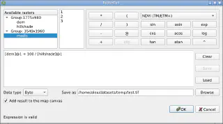
So… RasterCalc is a user-friendly and functional raster calculator written in Python. It was announced on the mailing lists on 16 January 2010.

RasterCalc was inspired by Barry Rowlingson’s RasterLang plugin. The main difference is the user-friendly interface and the familiar expression syntax (do you like LISP as much as Barry?). I have also added some additional features like saving and loading expressions, “templates” of formulas and extended the set of available functions and operators.
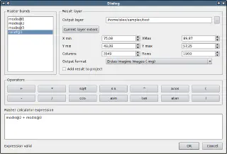
Weeks and months went by (I almost wrote “years”), nothing seemed to indicate any changes… And then, out of the blue, Marco Hugentobler and Tim Sutton decided to make RasterCalc part of the QGIS analysis library. This will allow its features to be used by other plugins, and remove the dependency on NumPy, pyparsing and other Python modules.
Marco has already published a first version of the patch. Some features are missing compared to the original plugin:
Float32 data typeAt the same time, new features have been added:

You can try out the new functionality by applying the patch and building QGIS from source. The calculator will appear in the “Layer → Raster calculator” menu.
The patch is still under development and some things may not work. The authors invite everyone to try it and report any bugs (if possible, attach a test dataset and steps to reproduce the issue).
Yay! The collaborative project to translate the QGIS 1.5 User Guide into Russian is finished. It took 1 month and 18 days, and 15 people participated.
During the translation process, many typos and inaccuracies were found, which, in the best tradition of open source, were corrected not only in the translated version but also in the original manual. Thanks to the perseverance of the project members, several major problems in the English version, such as the lack of a subject index and bibliography, have been fixed.
The translated user manual (PDF format, ~10 Mb) is now available on the QGIS website.