GdalTools — QGIS plugin for raster data processing
06.06.2010 13:07 · GIS · qgis, plugins, gdaltools
GdalTools (or Raster Tools) is a plugin for the open source GIS QGIS. The main purpose of the plugin is to simplify the use of the GDAL command line utilities by providing the user with a graphical interface for the most common operations.
Initially, the plugin was developed by Faunalia, later other developers, including myself, joined them. Robert Szczepanek created nice icons for most of the tools, and the development of some features was sponsored by Silvio Grosso.
At the time of the first announcement (September 2009), the plugin provided only two tools: gdalbuildvrt and gdal_contour. Now the number of integrated tools is approaching 20.
Installation
There are two versions of the plugin:
- stable (1.2.0 at the time of writing)
- experimental (potentially unstable but with new features and tools)
Both versions are available from the Faunalia repository. To install the experimental version, it is necessary to enable experimental plugins in the Python Plugin Installer, otherwise, the stable version of GdalTools will be installed. Since the stable version of GdalTools is included in QGIS 1.5.0, users of this (and any later) version don’t need to install it manually. However, they can replace the stable version with the experimental version from the repository if desired or necessary.
To install the GdalTools plugin from the repository, follow the steps below:
- open the Plugin Installer (“Plugins → Fetch Python Plugins…”)
- go to the “Repositories” tab and add third-party repositories by clicking on the “Add 3rd party repositories” button
- go to the “Options” tab and enable experimental plugins (“Show all plugins, even those marked as experimental”)
- go back to the «Plugins» tab and find “Gdal Tools” in the list of plugins
- select corresponding row and press “Install plugin” button
- wait until the plugin is downloaded and installed
- restart QGIS when asked
The plugin requires GDAL/OGR and the corresponding Python bindings. If QGIS is installed via the OSGeo4W installer, the required packages are called gdal16 and gdal16-python. If you are a Windows Vista/Seven user, please note that error messages may appear, check the OSGeo4W bugtracker for a solutions.
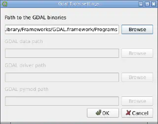
Mac OS X users should open the GdalTools settings dialogue box after installing the plugin and specify the directory where the GDAL utilities are located.

How does it work
Each tool requires the user to specify the input data (this can be either a layer loaded into QGIS or a file on disk) and configure some of the tool’s parameters.
This information is then used to generate a command line for the appropriate GDAL utility, which is then executed.

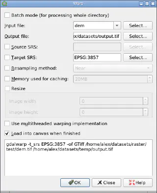
The generated command is displayed at the bottom of the tool’s window. If desired, it can be copied and run directly from the command line. This can be useful if you need to use additional options that are not available via the GUI.
Available tools
GdalTools now includes the following tools:
- Build Virtual Raster — creates a virtual raster (VRT) from a set of input files, uses
gdalbuildvrtunder the hood - Contour — generates a vector contour file from the input raster representing the elevation model (DEM), based on the
gdal_contourutility - Rasterize — used to transfer (“burn”) vector data (points, lines, polygons) into a raster file. Vectors are read from OGR-compatible data source, and must be in the same coordinate system as the raster. coordinate system as the raster. On-the-fly reprojection is not provided.
- Polygonize — creates vector polygons for all connected regions of pixels sharing a common pixel value. Each polygon is created with an attribute indicating the pixel value of that polygon. A raster mask may also be provided to determine which pixels are eligible for processing. This is a GUI for
gdal_rasterize - Merge — creates a mosaic from a set of images. All images must be in the same coordinate system and have the same number of bands, but they can have different resolutions. If there are overlaps, the last image is copied over earlier ones in such areas. This tool is a GUI for
gdal_mergeutility - Sieve — removes raster polygons smaller than a provided threshold size (in pixels) and replaces them with the pixel value of the largest neighbour polygon. The result can be written back to the existing raster band, or copied into a new file. Under the hood uses
gdal_sieve.pyscript - Proximity — generates a raster proximity map indicating the distance from the center of each pixel to the center of the nearest pixel identified as a target pixel. Target pixels are those in the source raster for which the raster pixel value is in the set of target pixel values. Uses
gdal_proximity.pyscript - Near Black — scans an input raster and tries to set all pixels that are nearly black (or nearly white) around the collar to exactly black (or white). This is often used to “fix up” lossy compressed rasters so that color pixels can be treated as transparent when mosaicing. Based on the
nearblackutility - Warp — reprojects the input raster to any supported projection. It can also apply GCPs stored with the image if the image is “raw” with control information. This tool supports batch mode, allowing multiple files to be reprojected at once. Based on the
gdalwarp - Grid — creates regular grid (raster) from the scattered data read from the OGR (vector) datasource. Input data will be interpolated to fill grid nodes with values, you can choose from various interpolation methods. Under the hood uses
gdal_grid - Translate — converts raster data between different formats. Like Warp, this tool can also work in batch mode, processing multiple input files at once. Uses
gdal_translateutility. - Information — lists various information about a raster, it is a GUI for
gdalinfotool - Assign Projection — assigns or replaces projection information for input raster. This tool supports batch mode and recursive directory traversal. Under the hood calls
gdalwarp. - Build Overviews — builds or rebuilds overviews (often called “pyramids”) for input rasters, supporting multiple downsampling algorithms. Overviews speed up the rendering of rasters. This tool supports batch mode and relies on the
gdaladdoutility. - Clipper — extracts a rectangular area from an input image or several neighbouring images and saves this fragment as a new raster. Uses
gdalwarp - RGB to PCT — computes an optimal pseudo-colour table for a given RGB raster and converts that raster into a pseudo-colored image. Supports batch processing, under the hood uses
rgb2pct - PCT to RGB — converts a pseudo-colour band of the input file into RGB raster in the desired format. Supports batch processing, under the hood uses
pct2rgb